

Background
The goal: Apartheid and Annexation
In a statement issued by the mayor of Ma’ale Adumim a few years ago, he explicitly and without diplomatic language revealed the true goals of the road: “This is a separate road for Palestinians in the E1 area whose purpose is to separate the transportation route between the Palestinian and Israeli population in the area, so that Palestinian vehicles can move without passing through Ma’ale Adumim Bloc, near Jewish settlements.” The message continues and explains the political implications of the road: “In the political sphere, the road will connect Jerusalem and Ma’ale Adumim and enable Jewish settlement construction in the E1 area.”
In an interview with Channel 13 in April 2025, his words were summarized as follows: “Without Palestinians – Israeli contiguity between Maale Adumim and Jerusalem.”

Former Mayor of Maale Adumim: “Without Palestinians – Israeli continuity from Maale Adumim to Jerusalem”
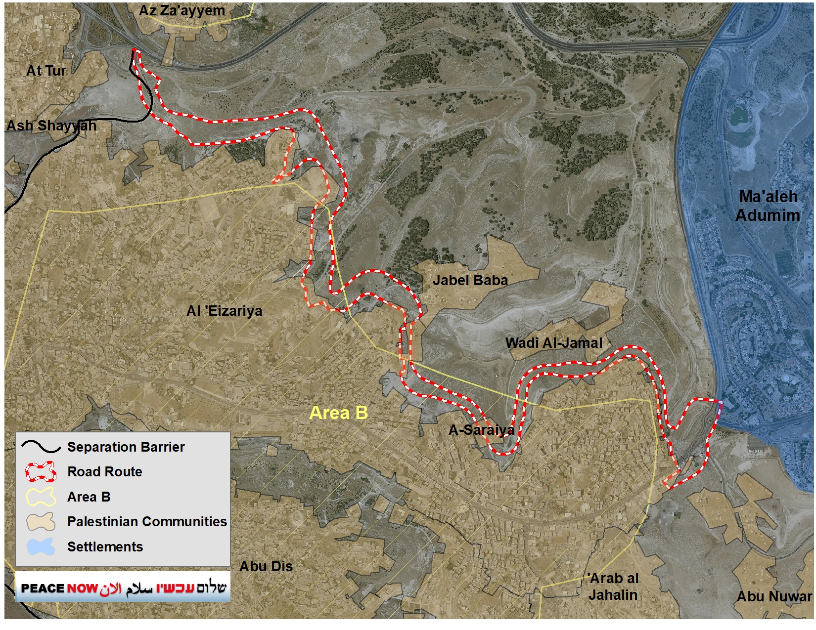
The impact on Palestinian communities
The construction of the road will have a deadly impact for the future Palestinian State and on the entire area in the heart of the West Bank. In addition, will also have a fatal and direct impact on Palestinians living near or within the area.
Dozens of Bedouin communities, like al-Khan Al-Ahmar residing within the area will be cut off from the rest of the West Bank, essentially by not having any access road to link them with the rest of the West Bank. This might lead to the displacement of thousands of Palestinians residing today in those communities.
Moreover, the communities of Wadi Jamal and Jabal Al-Baba, located near the planned road, which consist of hundreds of Palestinians, will be cut off from their surroundings due to the construction of the road. It is unknown how they will be able to cross the road and reach their own homes.
Furthermore, the road passes over established houses in the community of A-Saraiya, which is located in Area B. This means that these houses will be demolished. The demolition of the houses, like the entire process, is carried out by virtue of military seizure orders, that allows the Israeli authorities to temporal use of the land for security needs.
Residents of these Bedouin communities, together with the municipalities of Elazariya, Abu Dis, and Sawahra, petitioned the High Court of Justice (HCJ) in 2021 when the intention to pave the road was first announced. In response to the petition, the state argued that the petition was premature, and it was agreed between the parties that when there was an intention to carry out the construction, the petitioners would be notified in advance and given time to object.
Now, the Legal Advisor for Judea and Samaria has sent a letter to attorney Neta Amar-Sheif, who represents the petitioners, informing her of the construction of the road and granting her a period of 45 days to object:
“We hereby inform you that the military commander intends to implement the seizure orders … in light of the security need and the directive of the political echelon on the matter. It is clarified that, in accordance with the state’s undertaking in the above-mentioned petition, the seizure orders will not be implemented until at least 45 days have elapsed from the date of this notice.”
Bypassing the Planning Process
Officially, the planned road is defined as a “security road”. By being defined as a security road, it is not brought for planning approval in the Higher Planning Council of the Civil Administration. Subsequently, the public is not given the opportunity to object to it, as in a formal planning process.
Seemingly, this is because the State of Israel has no official authority to plan this road as significant parts of it pass through Area B (see map). According to the 1995 Interim Agreement between Israel and the Palestinians, planning authority in Area B is given only to the Palestinian Authority. To bypass this, the Ministry of Defense chose to define the road as a security road. The lands taken for its construction do not go through a process of confiscation for public purposes, but rather a process of military seizure, and the planning process is done behind closed doors.
Israel’s Plan: Transportational Contiguity in Place of Territorial Contiguity
The new road is intended to allow Palestinians to cut through the Adumim Bloc along a wall and as in a kind of tunnel. Once the road is paved, Israel can then claim that construction in E1 does not sever the West Bank because the Palestinians have an alternative transport route. This argument is preposterous. A thin line of road connecting separate territorial sections–transportational contiguity–does not meet the needs for territorial viability for the development and livelihoods of Palestinians in the critical Ramallah-Jerusalem-Bethlehem metropolitan area. Without actual territorial contiguity, an independent Palestinian state cannot be established and prosper, and therefore a two-state solution cannot be reached.
The two-state solution depends on the possibility of establishing a viable Palestinian state alongside Israel. The heart of the future Palestinian state geographically, economically, and culturally is in the metropolis between Ramallah, East Jerusalem and Bethlehem. One of the only potential development areas left for this metropolis are the areas east of Jerusalem, in the same area where Israel seeks to build the E1 settlement and create an Israeli territorial continuum from Jerusalem eastward that would effectively cut the West Bank in half.
See more about the issue in our report and video here.
